
Texas Flash Flood Emergency: Examining the Human Cost of Extreme Weather Events
Executive Summary
The devastating flash floods that struck central Texas and Kerr County during the Independence Day weekend represent one of the most catastrophic weather-related disasters in the region’s recent history. The tragedy, which claimed at least 105 lives including 28 children, highlights the vulnerability of communities to extreme weather events and the profound human cost of natural disasters in recreational and residential areas.

This comprehensive analysis examines the meteorological conditions that led to the flooding, the human impact on affected families and communities, emergency response challenges, and the broader implications for disaster preparedness and climate resilience. Through careful examination of witness accounts, emergency response efforts, and community impact, this report provides insights into the complex dynamics of flash flood disasters and their lasting effects on surviving family members and communities.
The case study focuses particularly on the experiences of families like the Burgess family, whose tragic story illustrates both the heroic efforts of parents to protect their children and the overwhelming power of natural forces during extreme weather events. Their experience serves as a representative example of the human elements underlying statistical casualty figures and emphasizes the importance of comprehensive disaster preparedness and response systems.
Meteorological Analysis and Flood Development
Atmospheric Conditions and Precipitation Patterns
The flash flooding event that devastated central Texas resulted from an exceptional convergence of meteorological factors that produced rainfall rates far exceeding normal parameters for the region. Weather analysis indicates that the affected areas received approximately one month’s worth of precipitation within a matter of hours, creating conditions that overwhelmed local drainage systems and natural watercourses.
The rapid accumulation of rainfall occurred during a period when atmospheric moisture content was unusually high, combined with slow-moving storm systems that concentrated precipitation over relatively small geographic areas. These conditions created what meteorologists term “training” thunderstorms, where multiple storm cells moved repeatedly over the same areas, compounding rainfall totals and increasing flood risk exponentially.
The intensity and duration of the precipitation event exceeded design parameters for local infrastructure and emergency planning scenarios, illustrating the challenges communities face when confronting weather events that fall outside historical experience ranges. The meteorological data from this event contributes to ongoing research about extreme weather patterns and their relationship to broader climate trends affecting the southwestern United States.
Hydrological Impact and River Systems
The Guadalupe River system, which serves as the primary drainage for much of the affected region, experienced unprecedented water level rises that transformed normally manageable waterways into dangerous torrents. River gauge data indicates that water levels rose to approximately 26 feet within a 45-minute period, creating conditions that provided minimal warning time for residents and emergency responders.
The rapid rise in water levels reflects the combined impact of intense rainfall over the river’s entire watershed, creating a concentrated surge of water that moved downstream faster than evacuation and emergency response systems could effectively manage. The speed of water level changes in flash flood events presents particular challenges for emergency management, as traditional flood warning systems may not provide adequate lead time for protective actions.
The hydrological analysis of this event provides valuable data for improving flood prediction models and emergency warning systems, particularly for communities located in areas susceptible to rapid water level changes. Understanding these dynamics is crucial for developing more effective protective measures and emergency response protocols for similar geographic and meteorological conditions.
Geographic Vulnerability and Land Use Factors
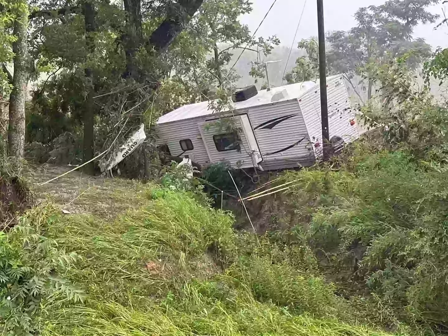
The areas most severely affected by the flooding included recreational vehicle parks, mobile home communities, and vacation rental facilities located in proximity to waterways during peak holiday occupancy. These land use patterns created conditions where large numbers of people, including many unfamiliar with local geography and evacuation routes, were concentrated in areas with high flood risk and limited emergency egress options.
The destruction of 28 recreational vehicles at the Blue Oak RV Park alone illustrates the vulnerability of temporary residential structures to flood conditions, while the displacement of mobile homes and vacation cabins demonstrates how quickly rising waters can overwhelm communities designed for recreational rather than permanent occupancy. These land use patterns require special consideration in emergency planning and flood risk assessment.
The holiday timing of the disaster meant that many affected individuals were visitors to the area who lacked familiarity with local emergency procedures, evacuation routes, and flood risk awareness. This factor complicated both immediate emergency response and ongoing recovery efforts, as emergency responders had to manage populations that included both local residents and temporary visitors with varying levels of local knowledge and preparation.