Severe Weather Alert: Tornado and Thunderstorm Watches Impact the Southern Plains
The National Weather Service’s Storm Prediction Center (SPC) has issued a significant warning for the Southern and Central Plains, raising the risk for severe thunderstorms and the potential development of tornadoes. With hazardous weather expected to worsen overnight, key cities such as Oklahoma City, Norman, Wichita Falls, Denton, and Lewisville are urged to remain vigilant. This report delves into the meteorological conditions driving the storm, the hazards it presents, and critical safety measures for residents in the affected areas.
Meteorological Overview: What’s Driving the Severe Weather?
A crucial component of this weather event is a mid-level short-wave trough. This trough, originating from the Four Corners region, is moving eastward and plays a significant role in triggering thunderstorms. As the trough moves into the southern Plains, it destabilizes the atmosphere by forcing warm, moist air upward, setting the stage for severe weather conditions.
Accompanying the trough is an advancing cold front, creating a clash between warm, moisture-laden air and cooler, drier air behind the front. This collision, known as frontal lifting, enhances storm formation by causing warm air to rise, contributing to the development of cumulonimbus clouds—the towering clouds responsible for thunderstorms. The ample moisture from the Gulf of Mexico adds to the severity of the storm, setting the stage for strong thunderstorms.
Wind shear, or the change in wind speed and direction with altitude, is also a key factor. Moderate to strong wind shear is expected in the region, creating the perfect conditions for the formation of supercells. These rotating storms have the potential to spawn tornadoes. The combination of instability from the warm air, the lift from the cold front, and the wind shear in the atmosphere enhances the chances of severe storms.
Regional Impact: What to Expect in Affected Areas
The SPC has issued an Enhanced Risk warning for regions in central Oklahoma, north Texas, and Kansas, where conditions are ripe for severe thunderstorms. Cities like Oklahoma City, Norman, Wichita Falls, Denton, and Lewisville fall within this warning zone, which means these areas are at an elevated risk for tornadoes, damaging wind gusts, and large hail. The storms are expected to intensify rapidly, with severe weather developing during the late afternoon or early evening and continuing into the overnight hours.
The primary threats include tornadoes, which form when thunderstorms, known as supercells, rotate and produce strong updrafts. The risk of damaging wind gusts is also high, with winds potentially exceeding 70 mph, capable of uprooting trees, damaging roofs, and disrupting power lines. Large hail could also cause significant damage to vehicles, crops, and buildings. Residents should be prepared to take shelter quickly and stay informed.
Tornado Watch: The Threat Expands
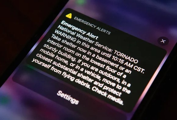
Alongside the Enhanced Risk warning, the SPC has issued a Tornado Watch covering parts of southwest Arkansas, southern and southeast Oklahoma, and northeastern Texas, in effect from 4:10 a.m. until 11:00 a.m. CST on March 4. This watch means conditions are favorable for tornado formation. Although a watch does not indicate that a tornado is imminent, it signals the need for residents to remain alert and ready to take action if a tornado warning is issued.
Communities in the Tornado Watch zone are advised to stay prepared. Local emergency services may increase readiness, and shelters could be opened for those seeking protection. Authorities will also use sirens, social media, and emergency broadcasts to keep the public informed.
Hazard Analysis: Multiple Risks in Play
Severe thunderstorms in the region pose several risks:
- Damaging Winds: Winds of over 70 mph can cause widespread damage, tearing off roofs, toppling trees, and breaking power lines.
- Large Hail: Hailstones could reach sizes large enough to cause significant damage to cars, crops, and buildings.
- Heavy Rain and Flash Flooding: Intense rainfall could lead to flash flooding, particularly in urban areas where drainage systems may be overwhelmed.
- Lightning: With increased thunderstorm activity, the risk of lightning strikes also rises, threatening both people and property.
The combined impact of these hazards can be overwhelming, damaging infrastructure, homes, and businesses while also threatening personal safety.
Safety Precautions and Preparedness Tips
Given the heightened risk of severe weather, residents are encouraged to take proactive steps to protect themselves and their property:
- Identify a Safe Room: Choose a small, interior room on the lowest level of your home to use as a safe room. Basements are ideal, but if unavailable, select a room without windows.
- Secure Outdoor Items: Bring in or secure loose items like patio furniture, garden tools, and decorations that could become dangerous projectiles in high winds.
- Stock Emergency Supplies: Prepare an emergency kit with water, non-perishable food, flashlights, batteries, a first-aid kit, and any necessary medications.
- Stay Informed: Download a reliable weather app, sign up for local alerts, and keep a battery-powered NOAA weather radio for updates.
If a tornado warning is issued, seek shelter immediately in the safest available space. Stay away from windows and listen for instructions. Those working outdoors should seek shelter and stay informed about changing weather conditions. Preparing in advance and staying informed can save lives during such intense weather events.
In conclusion, this severe weather event is expected to pose significant threats to communities in the Southern and Central Plains. Awareness, preparedness, and quick action can help mitigate the risks associated with tornadoes, damaging winds, and large hail.